Jet streams are primarily formed due to significant pressure differences between air masses, large bodies of air characterized by relatively consistent temperature and moisture levels.
The Coriolis force, influenced by the Earth’s rotation, plays a crucial role in shaping the behavior and direction of these high-speed aerial rivers. Jet streams are essential components of Earth’s atmospheric circulation, influencing global weather systems and serving as a fascinating subject of study for meteorologists and scientists.
Jet Streams
Jet streams are like nature’s high-speed aerial rivers, and they exhibit several distinct characteristics:
- Circumpolar Routes: These high-velocity air currents encircle the Earth, creating a circular path with the poles as their central points. They’re the atmospheric highways connecting the North and South Poles.
- Narrow Concentration: Jet streams are remarkably narrow, tightly concentrated air bands. The air within the stream is directed towards the axis of the stream, resulting in a very slender path typically measuring between 50 to 150 kilometers in width.
- Upper Tropospheric Altitude: Jet streams occupy the upper layers of the troposphere, the lowermost portion of Earth’s atmosphere. These streams can be found at significant altitudes, and their influence extends to the weather patterns below.
- Westerly Flow: One defining characteristic of jet streams is their westerly flow. They move from west to east across the globe, influencing weather and flight paths.
- Geostrophic Phenomena: Jet streams are considered geostrophic, which means they exhibit a balance between the Coriolis force and the pressure gradient force. This equilibrium results in their distinct behavior.
- High-Velocity Travelers: Jet streams are like express lanes in the atmosphere, traveling at remarkably high speeds. Their rapid motion impacts weather patterns, air travel times, and navigation strategies.
- Meandering Trajectories: Jet streams are typically well-defined and concentrated. They can exhibit a degree of meandering or curving. These meanders contribute to variations in weather patterns as they guide air masses along their path.
Understanding Geostrophic Wind and Atmospheric Circulation
In atmospheric science, geostrophic wind is a critical concept that sheds light on the movement of air masses in the upper layers of Earth’s atmosphere. It’s a fascinating interplay between forces, particularly the Coriolis force and pressure gradients, that influences wind behavior:
1. Coriolis Force and Wind: The Coriolis force is a consequence of the Earth’s rotation. It exerts its influence on moving objects, including air. Importantly, this force becomes more pronounced as the body’s velocity in motion increases. In the upper atmosphere, about 2-3 kilometers above the Earth’s surface, the air experiences minimal surface friction.
2. Geostrophic Wind: When conditions are met, such as straight isobars (lines connecting points of equal pressure) and the absence of surface friction, the Coriolis force balances the pressure gradient force. As a result, the wind flows parallel to the isobars, with the Coriolis force causing the maximum deflection. This wind is aptly named the geostrophic wind.
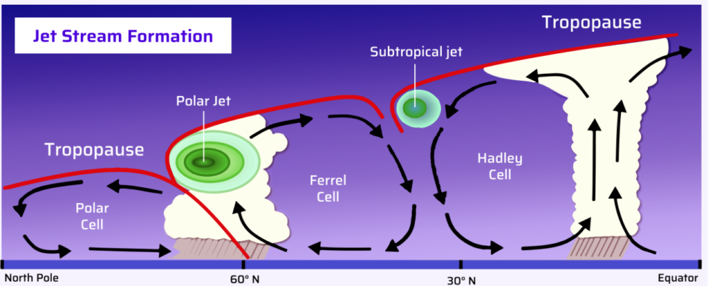
3. Deflection and Wind Cells: Now, the geostrophic winds in the upper troposphere are intriguing because they flow at high speeds due to the minimal friction they encounter. This leads to substantial deflection, giving rise to the formation of three distinct atmospheric circulation cells: the Hadley cell, the Ferrel cell, and the Polar cell.
4. Complex Circulation: These cells, each characterized by their unique properties, are responsible for the movement of air masses and play a significant role in shaping global weather patterns. The Hadley and Polar cells originate from thermal factors, primarily convection, while the Ferrel cell’s dynamics result from the interplay of Coriolis force and the blocking effect of converging winds. Together, these cells form an intricate web of atmospheric circulation known as the general circulation.
Exploring Upper Tropospheric Westerlies and Jet Streams
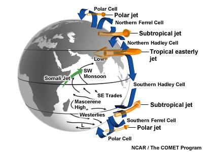
In the high altitudes of the Earth’s atmosphere, specifically just below the tropopause, a fascinating meteorological phenomenon unfolds – the creation of jet streams. These high-speed, concentrated air currents are set in motion by the movement of winds from the tropics towards the poles in the upper troposphere. They play a pivotal role in shaping our planet’s weather systems, and they come in two distinct forms in both the Northern and Southern Hemispheres.
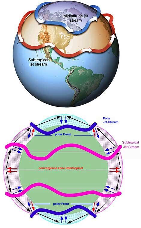
1. Polar Jet Stream: In the Northern Hemisphere, the polar jet stream is a powerful force to reckon with. It emerges due to the convergence of polar and temperate air masses. Winds within this jet stream flow from the temperate region towards the polar region. This stream separates the air masses, and its swift movement impacts weather patterns.
2. Subtropical Jet Stream: The subtropical jet stream, however, arises when temperate and tropical air masses meet. Here, winds flow from the subtropics towards the temperate region. This stream also wields its influence on climatic conditions, albeit differently from its polar counterpart.
In the upper troposphere, the rationale behind wind flow is primarily driven by thermal effects. It’s a matter of heat distribution – the poles receive less heat while the equator basks in warmth. This dichotomy leads to intriguing atmospheric dynamics: at the surface, winds move from the poles towards the equator, but at higher altitudes, the winds shift direction, flowing from the equator towards the poles. This thermal tug-of-war sets the stage for high-pressure gradients, with forces directed from the southern to the northern regions.
The Coriolis effect, an outcome of the Earth’s rotation, introduces yet another layer of complexity. Any motion from the tropics toward the poles incurs a deflection to the right in the Northern Hemisphere and the left in the Southern Hemisphere. Consequently, the jet streams, wherever they may be, traverse their paths from west to east, embracing a westerly direction in both hemispheres. This is why they are aptly referred to as westerlies or upper-level westerlies.
The upper tropospheric westerlies, or jet streams, embody a remarkable manifestation of the Earth’s intricate atmospheric ballet. They bridge the gap between thermal gradients, pressure systems, and the Coriolis effect, orchestrating the movements of our planet’s weather patterns on a grand scale. This harmonious dance of forces shapes the world we live in and keeps us intrigued by the ever-evolving drama of the skies.
Jet Streams: High Velocity
The speed demons of the upper atmosphere, jet streams, owe their velocity to a simple but crucial factor: temperature contrast. These high-altitude winds pick up their pace as the difference in temperature between the air masses increases. In other words, the larger the temperature gap, the faster these jet streams will zoom across the sky.
In the upper troposphere, where these air currents reside, friction takes a backseat. Why? Because the air is less dense at these lofty heights. It’s this reduced friction that allows jet streams to hurtle through the atmosphere at breakneck speeds. On average, they maintain a velocity of around 120 kilometers per hour during winter when the temperature contrast is at its peak. In the summertime, with a less pronounced temperature differential, their speed drops to approximately 50 kilometers per hour.
However, it’s essential to note that these are mere averages. Within the core of a jet stream, where their energies are most concentrated, speeds can be significantly higher. In some cases, these atmospheric racers can reach astonishing velocities of up to 400 kilometers per hour or even more.
Jet streams are like the supersonic speedsters of the upper atmosphere, propelled by the interplay of temperature gradients and the absence of atmospheric friction. Their ability to traverse great distances at such incredible speeds is one of the many marvels of Earth’s dynamic atmosphere.
Jet Stream Meandering: The Dance of Rossby Waves
Picture the jet stream as a swift and powerful river of air in the upper atmosphere, and you’ll start to understand its meandering behavior. The meandering of jet streams, often called Rossby waves, is intimately connected with the temperature contrast between air masses.
When the temperature contrast is at its zenith, jet streams flow in a nearly straight path, like a well-defined river channel. However, as this temperature contrast diminishes, the jet stream weakens, and its course takes on a wavy, meandering nature. In this meandering state, the jet stream no longer follows a straightforward path but moves in a zigzag pattern, with segments deviating toward the poles or the equator.
The degree of meandering depends on the strength of the temperature gradient. A robust temperature gradient creates a high-pressure gradient, resulting in greater wind speeds. These high-speed winds, in turn, generate a more significant Coriolis force. As a result, the wind behaves in a geostrophic manner, flowing parallel to the isobars and maintaining a predominantly west-to-east trajectory.
Conversely, a weaker temperature gradient leads to a less pronounced Coriolis force. Under these conditions, the wind begins to meander, creating the distinctive wavy pattern associated with Rossby waves.
In essence, the meandering of jet streams is a dance choreographed by temperature contrasts and the interplay of various atmospheric forces. It’s a dynamic feature of the Earth’s upper atmosphere that adds complexity and intrigue to our understanding of atmospheric circulation.
The Steady Course of Permanent Jet Streams
Two primary jet streams, the polar jet and the subtropical jet, maintain their positions in the upper troposphere most of the year. Let’s delve into the details of these perennial aerial currents.
1. Subtropical Jet Stream (STJ)
During winter, the subtropical jet stream flows continuously in the Northern and Southern Hemispheres. It maintains its presence throughout the year in the Southern Hemisphere. However, in the Northern Hemisphere’s summer, it temporarily shifts its location northward.
This occasional northward migration can be prompted by robust mid-latitude troughs, remnants of temperate cyclones extending into subtropical regions. In such instances, the subtropical jet may converge with the polar front jet—a phenomenon connected with cloudbursts, which we’ll explore further in the chapter on Indian Monsoons.
The subtropical jet stream plays a vital role in the context of the Indian and African summer monsoons, and we’ll delve into these connections in the chapter dedicated to Indian Monsoons.
2. Polar Front Jet (PFJ)
The polar jets, known as the polar front jet streams, are the most powerful among their counterparts, while the subtropical jets exhibit slightly less force. These polar jets exhibit greater variability in their positions. During summer, they migrate toward the poles, while in winter, they shift closer to the equator. The polar front jet stream maintains its strength and continuity throughout the winter months.
The polar front jet holds a profound influence over the climates of regions situated around the 60° latitude mark. Additionally, it plays a crucial role in shaping the trajectories, speeds, and intensities of temperate cyclones.
In summary, these permanent jet streams, both polar and subtropical, are vital components of the Earth’s atmospheric circulation. Their year-round presence and dynamism significantly impact weather patterns and climatic conditions in different parts of the world.
Intermittent Jet Streams: Seasonal Wanderers
Beyond the steadfast polar and subtropical jet streams, several temporary jet streams emerge only during specific seasons. These seasonal aerial currents play a significant role in influencing regional climatic patterns. Let’s explore two: the Somali Jet and the Tropical (African) Easterly Jet.
1. Somali Jet
The Somali Jet, characterized by south-westerly winds, typically manifests during the summer months over northern Madagascar and off the coast of Somalia. Its peak intensity occurs from June to August, making it a notable player in shaping the Indian Monsoons. This jet stream maintains its vigor relatively steadily from June through September, after which it gradually shifts towards the southern Indian Ocean during the winter season.
2. Tropical Easterly (TEJ) Jet or African Easterly Jet
The Tropical Easterly Jet, or TEJ, is a distinct and influential feature of the northern hemisphere’s summer season, primarily affecting southern Asia and northern Africa. Occupying the region between 5° and 20°N, the TEJ remains persistent in its location, direction, and intensity from June through the early days of October.
During the South Asian summer monsoon, the TEJ triggers secondary circulations that enhance convection over South India and the adjacent ocean. This jet stream is the upper-level venting system, pulling moisture for the robust southwest monsoon.
While the precise factors governing the formation and maintenance of the TEJ remain not entirely understood, it is believed to be associated with the unique climatic conditions over the Tibetan Plateau during the summer months. The encounter of dry air with more humid air at higher altitudes is thought to be a contributing factor.
In recent years, due to diminishing temperature disparities between the land and sea across the Indian subcontinent, the TEJ has exhibited a declining trend. This trend is a matter of concern as it has potential implications for the Indian monsoons.
The Impact of Jet Streams on Weather
Jet streams play a vital role in maintaining heat equilibrium across latitudes by facilitating the exchange of air masses. This exchange, in turn, influences the movement of air masses and can lead to extended periods of extreme weather conditions, such as heatwaves, droughts, or flooding.
1. Jet Streams and Indian Monsoons
In the context of India, both subtropical jet streams and certain temporary jet streams collectively influence the patterns of the Indian Monsoon. Detailed insights into this phenomenon will be explored in the section dedicated to Indian Monsoons in the field of Indian geography.
2. Jet Streams and Weather in Temperate Regions
Jet streams are instrumental in shifting air masses, redirecting weather systems to new locations, and, at times, causing them to stagnate if they’ve moved too far from their original positions.
The Polar Front Jet (PFJ) plays a pivotal role in shaping the weather of the mid-latitudes. It typically demarcates the boundary between the colder polar air masses and the warmer mid-latitude air masses. This demarcation significantly affects the trajectories and intensity of frontal precipitation and cyclones. When the PFJ weakens, it can result in the polar vortex encroaching into temperate regions, bringing about significant alterations in weather patterns.
The Impact of PFJ on Temperate Weather Patterns
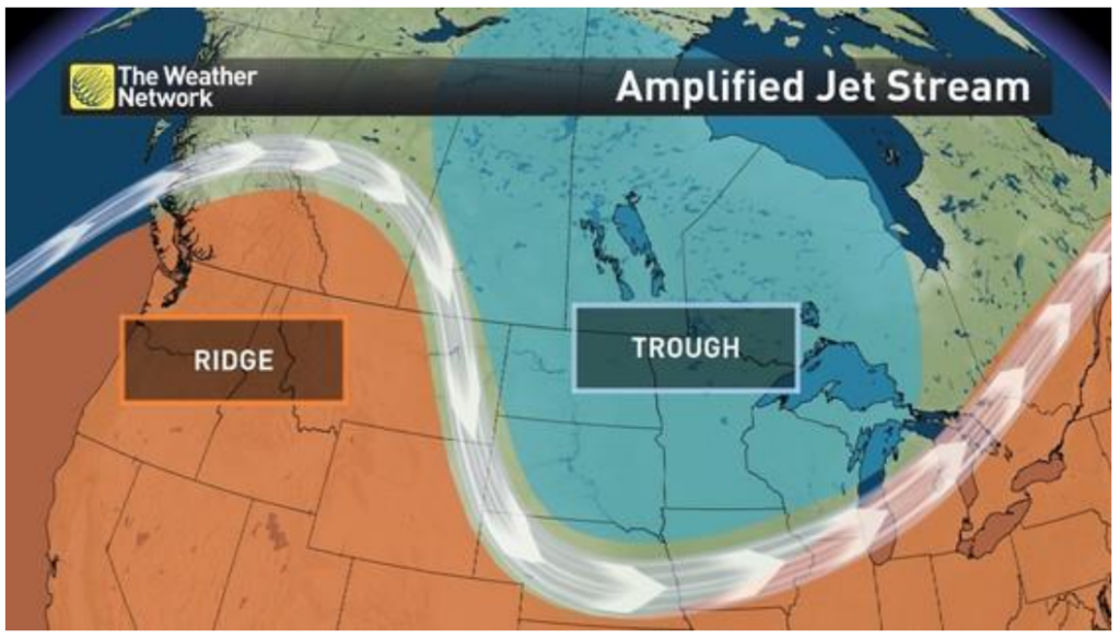
The Polar Front Jet (PFJ) plays a pivotal role in shaping temperate weather by orchestrating a series of weather phenomena, including troughing, ridging, and jet streaks. These concepts are essential for understanding weather patterns in temperate regions.
1. Ridges and Troughs
Ridges manifest when warm air, characterized by high pressure, pushes against the cold air. Troughs, on the other hand, are formed when cold air, corresponding to lower pressure, descends into warmer air. The occurrence of troughs and ridges results from a weakened jet stream, which implies a reduced temperature contrast between different air masses.
Troughs and ridges can be likened to low-pressure areas (troughs) and high-pressure zones (ridges). Weather dynamics vary significantly between these two phenomena. Weather conditions often precede a trough, while calm and stable weather typically prevails beneath a ridge.
2. Formation of Jet Streaks
Jet streaks emerge as a response to localized yet significant temperature disparities in the atmosphere. These are areas where wind patterns intensify.
3. Divergence and Low-Pressure Systems
When winds exit a trough or a jet streak, they create a process known as divergence, which generates a void in the upper atmosphere. This void is promptly filled by air ascending from lower altitudes, resulting in the formation of a low-pressure system. The Coriolis effect imparts a cyclonic rotation to these low-pressure systems, a characteristic often associated with depressions in weather patterns.
4. Convergence and High-Pressure Systems
In contrast, the winds entering a jet streak converge rapidly, giving rise to high-pressure conditions in the upper atmosphere. This, in turn, leads to divergence at the surface, establishing an anticyclonic pattern. The Coriolis effect contributes to the anticyclonic rotation, typically associated with clear and stable weather conditions.
If you Still confuse with Jet Stream formation and working ALSO READ THE POLAR VORTEX
Demystifying the Heat Dome and Omega Block
In July 2021, the town of Lytton in British Columbia, situated in the temperate region of South-Western Canada, experienced a staggering heatwave, with temperatures soaring to nearly 50 °C. These unprecedented scorching conditions were the handiwork of a meteorological phenomenon known as a heat dome.
1. Heat Dome Unveiled: A heat dome materializes when atmospheric conditions, particularly Rossby Waves, conspire to anchor a dome of high pressure several miles above the Earth’s surface. Within this dome, the air descends toward the ground and undergoes compression, elevating its temperature.
2. The Impact of Heat Domes: Heat domes wield the power to usher in sweltering temperatures, incite intense thunderstorms, and exacerbate the risk of hazardous wildfires. These wildfires are further fueled by pyrocumulonimbus clouds, intensifying their destructive potential.
3. Unraveling the Omega Block: Heat domes frequently give rise to atmospheric blocking patterns that effectively impede the typical west-to-east movement of weather systems. One of these patterns is aptly named the omega block.
4. The Omega Block Defined: As its name implies, the omega block adopts the shape of the Greek letter omega when depicted on a weather map. This configuration entails the establishment of zones of low pressure on both its western and eastern flanks. These low-pressure zones flank a central high-pressure region, the heat dome responsible for the scorching conditions.
Navigating Jet Streams in Aviation
Jet streams play a pivotal role in aviation, both as a boon and a challenge. Here’s how they influence the realm of flight:
1. Harnessing Jet Streams: Aviators often leverage the power of jet streams when their intended flight path aligns with the direction of these high-velocity air currents. By doing so, they can capitalize on the speed and efficiency that jet streams offer.
2. Steering Clear: Conversely, when aircraft are destined to travel against the grain of jet streams, they wisely opt to circumvent them. Attempting to fly against these formidable air currents can lead to inefficiency and increased travel time.
3. Turbulent Encounters: Jet streams have a reputation for unpredictability. This capricious nature can lead to turbulent flight conditions, even when the skies appear serene and clear. Pilots must be vigilant and prepared for sudden and unexpected movements.
4. Volcanic Intrigue: Jet streams are not just highways in the sky for airplanes. During volcanic eruptions, volcanic ash plumes can be drawn into the same jet streams aircraft rely on for their journeys. This phenomenon adds an extra layer of complexity and safety concerns for aviation during volcanic events.


