LOC VS LAC MAP
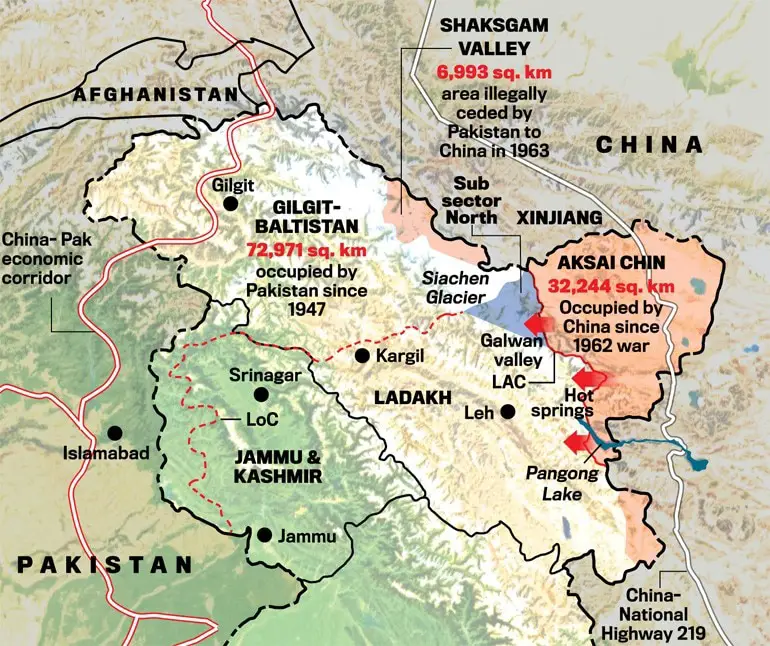
India has encountered various border-related disputes with its neighboring countries, notably China and Pakistan, which have intermittently escalated into armed conflicts. The Line of Actual Control (LAC) refers to the loosely defined border between India and China, including areas like Aksai Chin that lack clear demarcation. In contrast, the Line of Control (LOC) designates the well-defined military-marked frontier between India and Pakistan, particularly in the disputed region of Jammu and Kashmir. These border conflicts have been significant factors contributing to periods of tension and even warfare between the involved nations.
LOC
The Line of Control (LOC) pulsates with dynamic energy, witnessing frequent instances of firing and face-to-face interactions, serving as a stark demarcation meticulously defined by the military forces. Spanning approximately 776 kilometers in length, the LOC stands as a boundary separating parts of the Indian Union Territory of Jammu and Kashmir, which is under India’s control, from the illegally occupied territories by Pakistan. The Indian section of the LOC, encompassing the southern and eastern parts of the region, is commonly referred to as Jammu and Kashmir, constituting a substantial 45 percent of the entire Kashmir region.
LAC
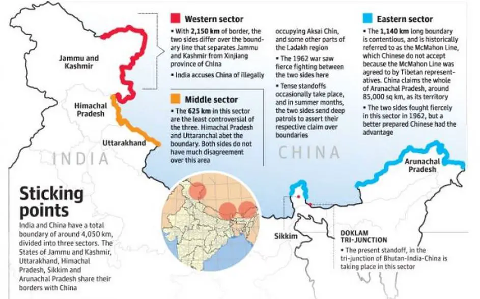
- The Line of Actual Control (LAC) serves as the demarcation line separating territories governed by India from those under Chinese administration. It spans a vast expanse, with a substantial gap of approximately 50 to 100 kilometers maintained by the armies of both countries.
- Discrepancies exist regarding the length of the LAC, with the Chinese government estimating it to be around 2,000 kilometers, while India’s assessment places it at a longer distance of 3,488 kilometers.
- The LAC is divided into three distinct sectors: the western sector in Ladakh, the middle sector in Uttarakhand, Himachal Pradesh, and Arunachal Pradesh, and the eastern sector encompassing Sikkim and parts of Arunachal Pradesh.
LOC VS LAC in brief
| LAC (Line of Actual Control) | LOC (Line of Control) | |
|---|---|---|
| Definition | The demarcation line between India and China | The demarcation line between India and Pakistan |
| Location | Borders India and China | Borders India and Pakistan, specifically in Jammu and Kashmir region |
| Settlement | No clear settlement of land positions between India and China | Defined military-marked frontier |
| Length | Approximately 2,000 km (according to China’s estimation) | Approximately 3,488 km (according to India’s estimation) |
| Divisions | Divided into three sectors: Western, Middle, and Eastern sectors | Single demarcated line |
| Activities | Occasional face-to-face interactions and border tensions | Active line with occasional firing and military activities |
| Control | Areas under respective administration with occasional border disputes | Controlled by Indian and Pakistani forces with disputed territories |
What are the originated differences between LAC (Line of Actual Control) and LOC (Line of Control)? | loc vs lac
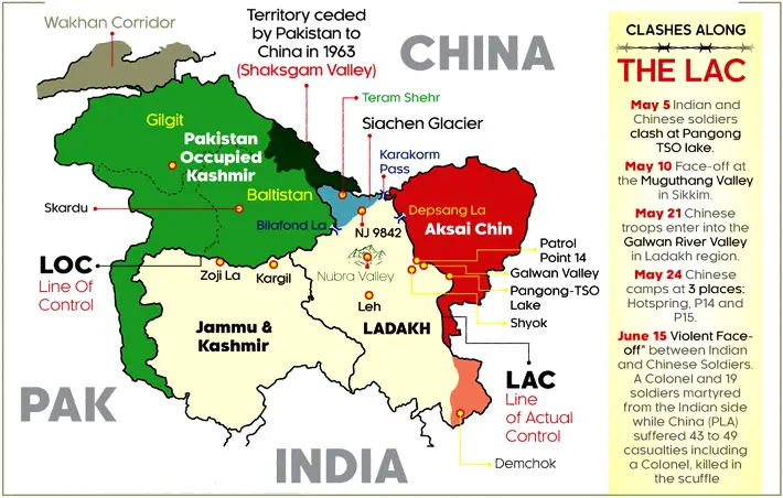
Following the conclusion of the Kashmir War, the Line of Control (LOC) materialized from the 1948 ceasefire line sanctioned by the United Nations (UN), establishing its historical significance. Subsequently, through the Shimla Agreement of 1972, the LOC acquired its official name, delineated on a map duly signed by the Director-General of Military Operations (DGMO) of both nations, thereby attaining the status of a legally binding treaty with international recognition.
In contrast, the Line of Actual Control (LAC) remains more fluid and conceptual, lacking consensus and formal demarcation on maps or on the ground, representing a differing approach between the two nations.
What are the ongoing conflicts between India and China along the Line of Actual Control (LAC)?
In the case of China, the Line of Actual Control (LAC) largely aligns with its asserted line of claim, although in the eastern sector, China claims the entirety of Arunachal Pradesh as part of South Tibet.
During the Indian Prime Minister’s visit to China in May 2015, the Chinese government declined to provide clarification on the LAC. Nevertheless, both China and India reiterated their commitment to promoting stability and tranquility in the border areas during the Wuhan Summit in 2018 and the Mahabalipuram Summit in 2019. The tense situation escalated significantly since May 2020, with clashes occurring at locations such as Galwan Valley and Pangong Tso Lake, resulting in casualties on both sides. As a consequence, the tensions along the LAC have greatly intensified.
India’s approach towards China’s aggression at Galwan Valley and Pangong Tso Lake in 2020.
Political response:
- The Indian government strongly condemned China’s aggression in the Galwan Valley and Pangong Tso Lake, asserting its commitment to defending the country’s territorial integrity.
- Diplomatic channels were actively utilized to engage with China and address the border standoff, emphasizing the need for peaceful resolution and adherence to bilateral agreements.
- High-level political discussions and negotiations were conducted to de-escalate tensions and restore stability in the region.
- Measures were taken to enhance border infrastructure and strengthen the military presence along the disputed areas as a deterrence against further aggression.
Social response:
- The Indian public expressed solidarity with the armed forces and paid tribute to the brave soldiers who lost their lives in the clashes.
- Social media platforms and other communication channels were used to raise awareness about the situation, mobilize support, and highlight the importance of national unity and defense.
- Citizens participated in campaigns and initiatives to promote self-reliance and reduce dependence on Chinese products.
- The incident sparked discussions and debates on national security, border issues, and India’s strategic relationships, fostering a sense of patriotism and unity among the populace.
Economic response:
- The Indian government implemented measures to review and restrict economic engagements with China, including trade restrictions and scrutiny of Chinese investments.
- India’s trade deficit with China witnessed a decline in the fiscal year 2019-2020, reaching $48.66 billion, primarily attributed to reduced imports. This marks a decrease compared to the trade deficit of $53.56 billion in 2018-19 and $63 billion in 2017-18. In addition to addressing trade imbalances.
- the Indian government has taken measures to mitigate potential risks associated with mobile applications. A ban on 59 apps, including popular Chinese platforms like TikTok, ShareIt, UCBrowser, and Weibo, has been implemented due to emerging concerns and the need to address potential risks associated with data security and user privacy.
- Emphasis was placed on promoting domestic industries and encouraging the manufacturing of essential goods within the country.
- Efforts were made to diversify trade partnerships and explore new markets to reduce reliance on Chinese imports.
- Economic stimulus packages and support were provided to sectors affected by the border tensions, fostering resilience and promoting indigenous industries.
The significance of Pangong Tso Lake in relation to the Line of Actual Control (LAC) is noteworthy.
In terms of governance, Pangong Tso Lake holds significance as it plays a role in defining the border and territorial claims between India and China. The Finger Sector, consisting of a series of eight cliffs extending from the Sirijap range on the northern bank of the lake, is a significant area of contention. While India asserts that Finger 8 marks the Line of Actual Control (LAC), its physical control is limited to Finger 4. Chinese border posts are present at Finger 8, whereas the LAC is believed to traverse near Finger 2.
Economically, Pangong Tso Lake has the potential to contribute to the economic development of the surrounding areas. The lake attracts tourists and serves as a valuable natural resource for fisheries and other economic activities. Ensuring secure and peaceful access to the lake is important for promoting economic growth and prosperity in the region.
Strategically, It is positioned along the Chushul approach, which is considered a critical route for China’s potential offensive into the Indian-held territory. Pangong Tso Lake’s location and control are of great importance. The control of the lake provides strategic advantages, including monitoring and surveillance capabilities, influencing the overall security posture in the region.

